
Part one covered the whole state, and provided the overall context - now let's look specifically at the Flinders Ranges -
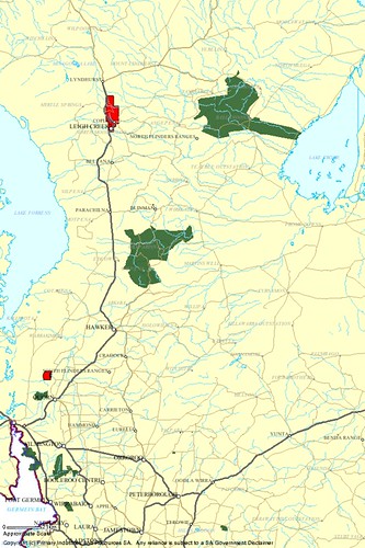
As with the previous set we're doing this in stages, the fully-protected, no mining access 'single proclamation' reserves are marked in dark green - that's, from the top, the Vulkathunha / Gammon Ranges and Flinders Ranges National Parks, the Dutchman's Stern and (on the coast) Winniowie Conservation Parks, a bit over half of the Mount Remarkable National Park, and the Telowie Gorge Conservation Park.
(Click the image to go to the Flickr site for larger versions of each image and considerably more detail)
And, in the red corner, the 'Areas Excluded from the Mining Act' - firstly up top the Leigh Creek Coalfield - which is, you may have noted a mine, a coal mine, and a very big one at that! If you're a South Aussie and you've not switched to renewable power yet this is what largely does the magic for you when you flick the light switch! And it's status as an 'Area Excluded' from mining is, um, debateable.
Not debateable - and a living testament to a Ministerial power not often used - is the Warren Gorge above the Dutchman's Stern CP and Quorn, excluded 'to prevent further mining in a scenic area'. Hoorah! Now, Warren is very pretty and I'm glad it's preserved, but it's not a patch on Arkaroola either aesthetically or in biodiversity importance terms.
Again, as with the previous maps, otherwise the remainder of the area of the region is available to the mining and petroleum industry.
Deep breath - here come the 'joint-proclamation', mining industry accessible parks -
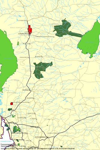
A splash of light green. Again, consistent with the state as a whole, it's a considerably greater area than the dark green, fully-protected reserves. Lake Frome Conservation Park lies to the east, Lake Torrens National Park to the west. Track down the map to all of Mount Brown CP south of Quorn, the rest of Mount Remarkable NP - does anyone really imagine the public would tolerate a significant mining program in Mount Remarkable, by the way? - and that funny little widely-separated extension of Mount Remarkable below The Bluff east of Port Pirie.
Yes, I missed one. That's because I think it's worth noting that the Ediacara Conservation Park - east of Lake Torrens and west of Beltana - set aside specifically to preserve a unique set of fossils of global heritage significance, is a joint-proclamation - and so accessible by the mining industry! It also has a separate 'restricted access' status as a 'fossil reserve'. But what does this actually mean - is it theoretically mineable, or not? At any rate, it's currently covered in leases - see below.
I'll also note some absences in passing - no protection for spectacular Mount Chambers Gorge between the Flinders Ranges NP and Lake Frome, nor for the Parachilna Gorge west of Blinman, nor Patawarta Hill, nor the Devil's Peak, nor the Bendleby Ranges. Etcetera; I'll leave you to name your own favourite other, 'non-Parky' bits of the Flinders. Then keep an eye on them as we turn on the lease mapping layers -
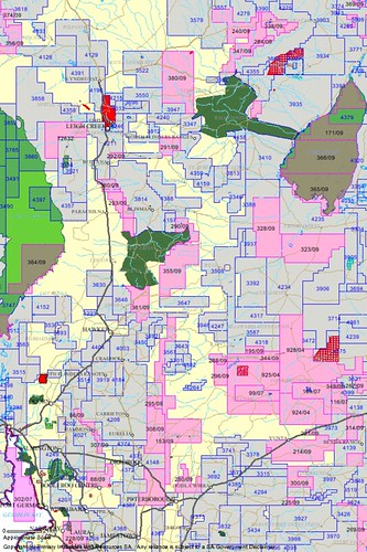
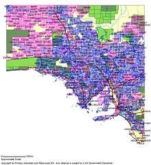
Do I really need to make further comment? The cross-hatched red bits that just appeared are 'production tenements' i.e places where mining is approved to or can actually occur- notably Heathgate's Beverley Uranium deposits adjacent to the Arkaroola Wilderness Sanctuary, which lies north of the Vulkathunha / Gammons Park, but you can't see it for reasons I'll explain below.
It only remains to add the Petroleum industry component -
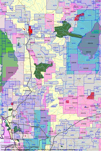
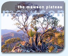
Wow, now we have the Petroleum Exploration encroaching on the Mawson Plateau too! Can anyone really defend this kind of thing? And if you're going to say 'it's only an arbitrary lease boundary, they wouldn't actually do it' why not embrace the opportunity to formalise that 'excluded' status and have me pipe down for a while?
Lastly, let's have a look at the actual area that Seeking a Balance focuses on, now that we've actually provided the context that SaB very clearly lacks -
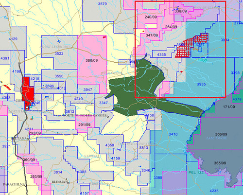
The overall area is roughly the same as that shown in the context mapping in the SaB document, and the red inset rectangle represents the area that is targetted for its specific proposed Access Zones; these are focussed mainly on the Arkaroola region.
The Arkaroola Wilderness Sanctuary - like the other Flinders Ranges features I've 'pointed out' (or can't!) above - is not visible here because that's the way successive state governments have chosen to render it in mining industry terms!
What can we conclude from all this?
i heart the mining industry?
Did you see the movie 'I Heart Huckabees'? Despite its being an obvious satire, I thought it made one serious point rather well. (And no, I can't find the clip on YouTube! Sing out if you know better...)
The fictional environmental organisation that its protagonist was the head of presented a fictional television advertisement I thought summed up the problem with 'balancing' transactions between natural and human demands nicely.
Start with the main character centre-screen announcing a conflict between commercial/industrial 'development' and natural values in a remnant natural region, announce 'Well, let's make a compromise - we'll [meaning development proponents] just take half!'; half the TV screen blacks out.
The figure sidesteps to be visible in that half, announces a new development/conservation conflict over the remaining area, and another 'balanced' 50/50 compromise; now the top half of the half of the screen that was still visible blacks out. Overall 3/4 of the screen is now black.
The main character stoops to get his head into remaining visible quarter, indicates yet another conflict over this area, proposes the same 'balanced' solution; 7/8ths now black... You get the idea!
Now, we've already reached a state where most of the natural communities in the southern section of the state have been driven into tiny pockets by the 'Europeanising' process inherent in settlement. High-quality natural communities now occupy a tiny fraction of their original extent, and an even tinier fraction of the area of the state. To then frame these pockets as the venue for some sort of 'reasonable compromise' between conservation and yet more disturbance, as satirised by the movie's commercial, is not only inherently absurd, it's 'globally' absurd before the process has even begun! That is what publishing these maps is intended to demonstrate.
The very concept of 'seeking a balance' in the northern Flinders implies that some sort of an 'all else being equal' state might prevail between conservation and mining access elsewhere in the state - and this very, very far from being the case.
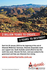
Now, best practice mining and exploration is very important, and it's great that this has had government and industry support. But the thriving mining industry in this state, if it wishes to fully lay claim to the mantle of environmental responsibility, should accept with good grace that there are areas that are too precious to mine. I call on it to make a start right here in Arkaroola.
In fact, I'd argue that both the industry, and the state government, stand to benefit overall by embracing the concept as part of their own commitment to best-practice, and by beginning a good faith process of relinquishing claims to our unique, high-value remnant natural legacy.
on a technical note
All these maps were taken from Primary Industries and Resources SA's excellent South Australian Resource Information Geoserver. (Ironically, I may be SARIG's biggest fan!)
Images © PIRSA SARIG geoserver 2010 - https://egate.pir.sa.gov.au/geoserver/sarig/frameSet.jsp
![link to the u[n]sa homepage](http://users.chariot.net.au/~greenh/blog/unknownsa_ublog-text.gif)

![link to the u[n]sa features page](http://users.chariot.net.au/~greenh/blog/features_ublog-text.gif)
![link to the u[n]sa kangaroo island feature image pages](http://farm2.static.flickr.com/1306/1187313059_93fdefd86b_o.jpg)
![link to the u[n]sa katarapko creek / murray river np feature image pages](http://farm2.static.flickr.com/1435/1181073355_b5c45f799d_o.jpg)


!['constellation' - wild country [national] set on flickr](http://farm1.static.flickr.com/155/415123844_3e6da621e5_s.jpg)

!['the bay serene' - the wild west [coast] set on flickr](http://farm1.static.flickr.com/121/312226516_606ac35455_s.jpg)


![u[n]sa journal - thanks for your time!](http://users.chariot.net.au/~greenh/blog/journal_ublog-text.gif "u[n]sa journal -thanks for your time!")
No comments:
Post a Comment
thanks for your contribution - bill - i'm genuinely sorry about having to switch on the 'moderation' process but comment spammers have really been cluttering up this journal!